People are more alike than different. (Polus Center)
x Education is not the filling of a pail, but
the lighting of
a fire. (William Butler Yeats)
x Wasting less is more patriotic than buying
more.
(Eric Liu &
Nick Hanauer)
x Read
more of my
Quotes for All
Moments
This
site has
hundreds of
pages --
please start
with these!
The
reason I am
here. Everything on my site is ultimately for my
students, but
this section
is
particularly
for them. It
provides
information on
the specific
courses I
teach (including
textbook
selections for
upcoming
semesters),
my
expectations
and advice for
students,
detailed
contact
information.
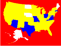
Two
versions of
the PSA from My Wonderful World. See more
about this
campaign
below.
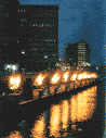
I get
around. My life is one big field trip -- I love
places and the
people who
make them
unique. This
part of my
site shows
where I have
been and what
I have been
learning --
music, coffee,
tea,
chocolate,
cities and
rain forests
from Brazil to
Transylvania,
from Nicaragua
to Cape Verde,
from Cuba to
Kenya -- and
most of the
United States.
We have
a whole planet
to save here! Read
about my
environmental
projects and
many others
that I
support. The
planet -- or
neighborhood
-- you save
may be your
own.
A few
hundred of my
favorite
sites. I have been pursuing a wide variety of
interests
online since
before Google
or Yahoo were
even thougth
of. Many of my
favorite pages
are here, with
annotations,
including many
I have created
myself.
All
about me. Catch
up with my
family and
favorite
activities.
Also see my
photos and
favorites on
Flickr,
YouTube, IMDB,
and other
online
communities.
Study in Brazil -- We'll Pay for It!
The U.S.-Brazil Consortium
in Urban
Development
funding
for several
years of
semester-long
exchanges to
study the role
of geography
in urban
planning in
southern
Brazil and New
England.
The
idea
originated
with
presidents
Bill Clinton
and Fernando
Henrique
Cardoso. It
continues to
be funded by
the federal
governments of
each country.
Look over the
web site, and
contact me if
you would like
to
participate.
Geography
is what
geographers
do.
As I
have
reorganized
this site, I
decided that
the rest of
this main page
should include
a few specific
examples of
what geography
is all about.
For more
detailed
discussion,
see my "
What is
Environmental
Geography
?" page or the
PodCast
I recorded
with
colleagues
Harm de Blij
and Vernon
Domingo.
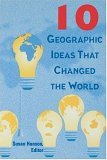
For more
examples, see
Ten
Geographic
Ideas ,
which I
adapted from
the book by
Susan Hanson.
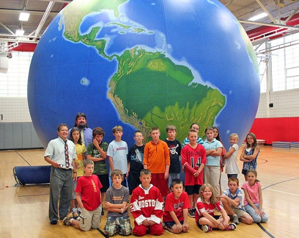
See the
world inside
& out! BSC's
Traveling EarthView or Boston's Glass Mapparium
Follow
EarthView at
our EarthView
Blog
For fun right
now, see my GeoGames page
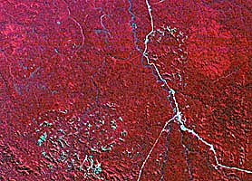
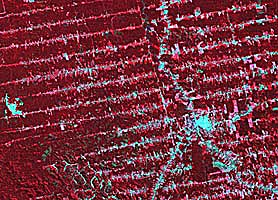
Rain
Forest
Geography
I got started
in
environmental
geography in
the 1980s when
a friend
talked me into
taking a
single course,
in which I
ended up
learning quite
a bit about
deforestation
in the Amazon
Basin.
Eventually, I
went to
Rondonia, one
of the most
damaged parts
of the
Brazilian rain
forest. The
two LANDSAT
images above
provide a
wealth of
environmental
geography
lessons; I
have used
these images
when teaching
about
biodiversity,
the geography
of Latin
America, and
the
applications
of remote
sensing. The
image on the
left shows a
part of
central
Rondonia in
1975; the same
area is shown
in 1992 on the
right. During
these years,
the Brazilian
government
funded the
building of
small roads at
10-kilometer
intervals
along BR-364,
the main
highway that
runs from the
SE corner to
the northern
part of each
image. By
1992, it is
difficult to
see the
highway
because of all
the clearing
that ensued.
Learn more
about what
happened in
the Rondonia Web
portion of
this site. It
includes links
to a USGS site
about the
images
themselves, to
an online
photodocumentary
by my friend
Lee Clockman,
and all of my
writings about
the area.
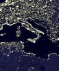
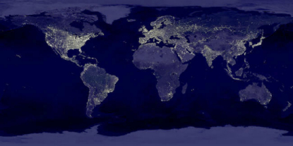
Earth
at Night
This
image mosaic
from NASA is
an excellent
geography
lesson. Light
is a
reasonable
proxy for
population, so
this image
works for an
initial
discussion of
the places
where humans
live in large
numbers, and
the places
that human
settlement is
more
difficult.
Generally, the
places that do
not support
agriculture do
not support
large numbers
of humans,
unless an
ecomomy is
strong enough
to be
sustained on
some other
basis. Look
for other
interesting or
unusual
population
patterns
throughout the
mosaic.
Because light
is a
reasonable but
not perfect
proxy, this
image also
shows reveals
real
discrepencies
in technology
and economy.
Notice, for
example, that
South Korea
appears almost
as an island,
because North
Korea is
barely
visible.
Similarly, the
distribution
of population
in Egypt
exhibits a
form not found
anywhere else
on the planet.
Click on the
image to go to
the original APOD page
, where
technical
information
and a
higher-resolution
version of the
image are
provided.
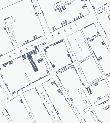
John
Snow --
Geography of
Public Health
Geographers
like
to
site
the
work
of
John Snow , a
nineteenth-century
London
physician,
when
explaining the
value of a
spatial
perspective.
By mapping the
incidence of
cholera, he
was able to
identify the
water supply
as a source of
transmission,
and saved
lives by
having the
handle removed
from a
particular
well. A
similar
technique was
used to
discover the
grave problems
at Love Canal
near Niagara
Falls more
than a century
later. The
image above
comes from an
article about Snow
posted by the
Center for
Spatially
Integrated
Social Science
at UC-Santa
Barbara.
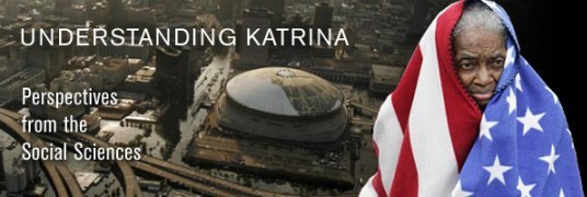
Hurricane
Katrina
Some
consider
Hurricane
Katrina to be
the worst
natural
disaster in
recent U.S.
experience.
Many
geographers do
not consider
it a "natural"
disaster at
all, but
rather as a
terrible event
that exposed a
variety of
underlying
problems. It
may be the
case that
human-induced
climate change
contributed to
the severity
of the storm.
It is
definitely the
case that
human-induced
climate change
has raised sea
levels, so
that the storm
surge occurred
from a higher
base
elevation.
More
importantly,
human-induced
coastal
erosion had
removed
protective
physical
barriers. Understanding
Katrina is
a collection
of essays by
geographers
and other
social
sciences that
examines what
Katrina has
revealed about
our society.
For a brief
explanation of
why Katrina
cannot be more
directly
attributed to
climate
change, see
the brief
article on
Katrina from
the Pew Center
on Global
Climate
Change.
Although
climate change
cannot be
"blamed" for
this disaster,
geographers
understand
that climate
change are
likely to make
such events
even more
problematic
into the
future.
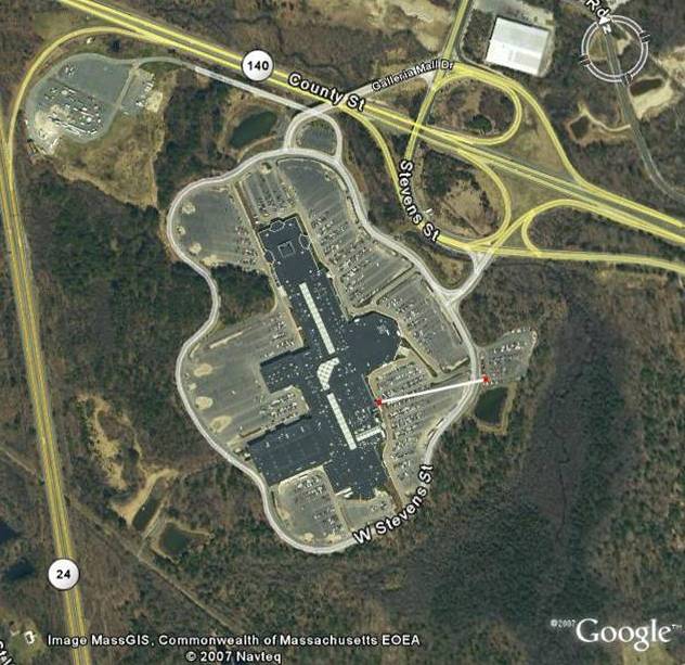
Sprawl
This example
-- an aerial
view of the
Silver City
Galleria Mall
in Taunton,
Massachusetts
-- is
closer to home
and
illustrates
several
interesting
things. First,
geographic
information is
increasingly
easy to
obtain,
especially in
areas where
government
agencies (such
as MassGIS) have
generously
supported the
free
publication of
data. Second,
it is often
possible to
learn
something
about local
geography from
place names.
In this case,
Silver City
refers to
Taunton's past
as an
important
center for the
production of
fine silver
pieces. Third,
this is a fine
example of the
attraction of
transportation
nodes. A large
piece of open
land near the
intersection
of two major
highways is
unlikely to
remain open
for long, as
the value at
such a site
will
eventually
make
development
too attractive
to resist.
Finally,
notice the
white bar on
the eastern
side of the
complex. It
measures 600
feet from the
entrance to
the food court
to the
overflow
parking area.
This is a
figure I
learned from Edge
City ,
Joel Garreau's
classic book
on suburban
sprawl: It is
the maximum
distance a
U.S. resident
will
voluntarily
walk without
being tricked.
A perfect
example is in
the mall
itself. The
white stripe
in the center
of the mall is
a skylight in
the main
concourse. The
fact that the
concourse is a
total of one
thousand feet
long might be
cited as
evidence to
contradict
Garreau,
except for one
thing: the
dog-leg in the
center of the
mall --
clearly
visible in
this image --
is a visual
trick that
induces
customers to
walk the
"entire"
length.
Geography is
concerned with
the many
implications
of this simple
observation.
Over a period
of five to six
decades, the
United States
has developed
a dependency
on the
automobile
that is
self-perpetuating.
Things must be
spread out to
make room for
cars, and cars
are needed to
navigate the
spread-outness
of suburbia.
The fact that
this aspect of
"progress" is
now becoming
common in
developing
countries was
one of my
motivations in
establishing
the U.S.-Brazil Consortium
in Urban
Development,
which gives
students at
BSC and
partner
universities
the
opportunity to
study these
problems in
detail.
Also, see my Geography
of
Suburban
Sprawl
page, which is
based on a
presentation I
made to the
Massachusetts
Association of
Conservation
Commissioners.
Sprawl
Redux -- The
Playground
Problem
I took this
photo in
suburban
Maryland in
the summer of
2007, because
this single,
back-yard
vista so
thoroughly
captures much
of what is
wrong with the
suburban
geography of
the United
States today.
First,
Americans are
increasingly
moving away
from each
other, even in
individual
neighborhoods.
The space
between houses
is the result
of mandated
low density,
which is
intended to
reduce the
impact of
development.
In fact,
however, it
increases the
need to drive
for most
errands. (In
fairness, I
was standing
on the edge of
a
newly-constructed
shopping area
that intends
to serve some
of the routine
needs of these
houses --
including
ready-to-heat
dinners for
families who
no longer
cook, though
they have
state-of-the
art kitchens.)
What has
become
"normal" in
house sizes
would have
been
considered
ostentatious
only a couple
of generations
ago. Much of
the extra
space is
devoted to
storing the
stuff acquired
on shopping
excursions,
aimless
shopping
having become
the nation's
leading
pastime.
Typically,
families in
such
over-sized
houses find
that they
"cocoon" in a
few
comfortable
rooms, though
they furnish,
heat, and air
condition up
to three or
four thousand
square feet of
space. The
playgrounds
themselves
exemplify the
costs of a
diminished
sense of
community,
along with a
rigid
opposition to
taxation. Many
Americans
would now
rather spend a
few thousand
dollars on the
play
structures
their own
children
demand than
contribute a
few hundred
extra dollars
to
neighborhood
facilities.
The inward
focus,
combined with
a general fear
of letting
children out
of sight,
leads to vast
areas of land
devoted to
unused,
single-family
playgrounds
and an
increasing
sense of
isolation.
Notice the
distinct lack
of children in
this
photograph!
New urbanism
is an effort
to reverse
these
pernicious
trends, by
bringing
people back in
close
proximity to
each other,
with
architecture
that is
interesting,
services that
are available,
and community
goods that
create a
shared
experience. I
live in such a
neighborhood
in
Massachusetts,
on 0.31 acres,
with
playgrounds
and shops we
can walk to,
but even in my
town it would
be illegal to
build such a
neighborhood
today! The
result of this
imbalance is
increased time
spent in cars,
decreased time
spent with
neighbors,
huge amounts
of money spent
on fossil
fuels, and a
worsening
climate.
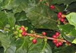
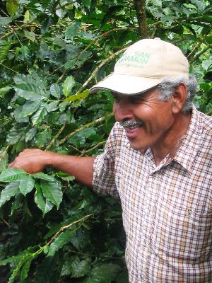
Geography
of Coffee
Coffee
is the
second-most
traded
commodity in
the world,
after oil. It
employs
millions of
people who
grow, process,
transport,
market,
prepare, and
serve it.
These people
are connected
in complex
relationships
that span the
globe, and
that exemplify
the
interconnectedness
that
characterizes
the 21st
century.
From this
farmer in
Matagalpa,
Nicaragua to
the barista at
the corner
shop, coffee
people are
part of a very
interesting
geography.
Coffee
originated in
Yemen, but
through the
process of
colonization
it is now
found
throughout the
tropics.
Within this
broad range,
the quality
and
productivity
of coffee
varies
according to
many
locational
factors. The
knowledgeable
farmers of
Matagalpa
produce some
of the best
coffee in the
world, aided
by the
abundant,
gentle rains
of the cloud
forests and
rich, volcanic
soils.
Historically,
coffee was
harvested by
slaves, and
today many
work in
conditions
that are not
noticeably
better. The
fair trade
movement is an
effort to
transform the
economic
geography of
the industry
into a more
equitable
form. The
human
geography of
coffee also
includes the
role of coffee
shops as nodes
of local
community
building and
as incubators
of
intellectual,
political, and
financial
pursuits.
My Geography
of Coffee
pages describe
my
explorations
of coffee --
from the field
to the cup!
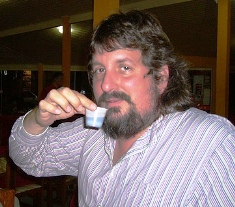
Geography
for Global
Education
My
friend
and colleague
Vernon Domingo
took this
photo of me
just in time
for it to
circulate
among friends,
family, and
students on
46th birthday.
It does look
rather like a
peculiar birth
of a
geographer. In
reality, the
photo shows me
in the process
of deflating EarthView after a day of
teaching at
Trinity
Catholic
Academy, one
of a couple
dozen places
we have
visited,
sharing the
wonders of the
world with
close to
10,000
students in
the first year
of the
program.
This brings us
to what is
perhaps the
most commonly
recognized use
of geography:
a systematic
way to learn
about the
world.
Geography is a
vital part of
education for
global
citizenship,
as the world
space-economy
continues to
collapse
physical
distance.
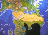
Fiji, for
example, is
shown just
above my head
in this photo
and is
actually a
source of
bottled water
sold in the
United States
-- it could
hardly be
farther away,
and yet it is
connected.
Geography
helps citizens
and consumers
to
understand
complex webs
of connections
to each other
and to the
earth across
great
distances.
Often just one
or two
connections
are known,
when the
understanding
of many more
connections is
necessary to
make informed
choices.
Geography
education is
vital for
effective
global
citizenship
and it is
increasingly
important for
employment, as
geospatial
skills are
integrated
into many
kinds of work.
It is for this
reason that I
am involved in
National
Geographic's
campaign for Geographic
Literacy by
2025. Part
of that
campaign is
the very
engaging My
Wonderful
World
program.
Geography is What
Geographers Do
This
tautology is
an invitation
to consider
the very wide
variety in the
field of
geography --
both in terms
of what
geographers do
but also who
geographers
are. Within
the AAG --
North
America's
major
professional
society for
geographers --
dozens of
groups have
formed to
explore common
interests or
identities. To
read the list
of specialty
and affinity
groups is
to begin to
understand the
many ways that
a geographic
perspective
can help to
make sense of
a complex
world.
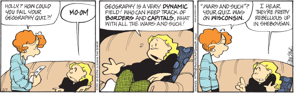
GEOGRAPHY
IS MORE THAN
QUIZZES, BUT
QUIZZES HELP (c) 2008 Jan Eliot /
permission
pending BUILD
YOUR KNOWLEDGE
WITH MY NEW GeoGames PAGE!
Bridgewater
State
University
encourages
publishing
on
the
web
site.
Content
and
organization
are
the
responsibility
of
the
author.
The
views
expressed
on
these
pages
are
those
of
the author and
may not
necessarily
represent the
opinions of
Bridgewater
State
University.