| County Map
Project Revised November 28, 2007 |
Not all who wander are lost.
~ J.R.R. Tolkien ~
|
| James Hayes-Bohanan, Ph.D.
Department of Geography Bridgewater State College With valuable assistance from Andrea Peters, Jacqie Lourenco, Kim O'Connell, Leah Chuckran, and Mia Mercado, and the comments of site visitors and my students. |
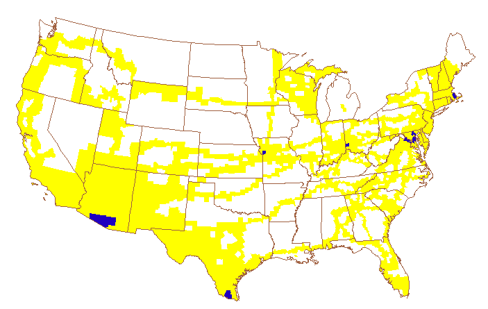
| I love to travel -- at
home and abroad -- and I have been lucky enough to visit 46 of the 50
United States, and over 1300 of is 3140 counties. In nine states -- AZ,
CT, DE, MA, MD, NH, NJ, RI, and VT -- I have been to every county.
These maps constitute my life list (though I am a little behind in
Vermont, Michigan, and New York). This page is where I try to keep track, and it has links to stories, maps, and photos of some of the places I've been fortunate enough to visit. |

Visit my State Postcard
Collection page! For states from which I do not yet have a
postcard, please feel
free to contribute to my growing collection, and thanks to those who
already have.
I have not been to nearly as many coffee shops as I have
counties, but I am trying. See my Geography of Coffee Shoppes
page for a sampling!
Learn about the history of this project, related links, and how to build your own site on the ABOUT CMP page. Think you know the United States like the back of your hand? Try this game.