County Map ProjectCA - California
|
County Map ProjectCA - California
|
 I have visited California several
times, each in a different part. I still think I have only scratched
the surface.
I have visited California several
times, each in a different part. I still think I have only scratched
the surface.
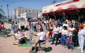
My first visit was to Glendale, in greater Los Angeles, where the
sister of my traveling buddy Mike lived. We spent most of our time at
beaches, including
the famous and funky Venice Beach. To learn more, visit Jeff Stanton's Visit Venice
site,
which includes more photos, a web cam, and a history of this legendary
beach
community. You can also visit the Venice web portal Venice Beach.com.
So far, I have visited the counties shown in yellow.
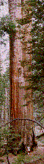 On a later visit, I had the privilege of seeing many of the coastal
redwoods
of the northern California. Only four percent of these trees remain,
and
cutting continues. I was impressed by the beauty of the trees, the
abundant
wildlife, and also by the destruction that is under way just off the
main
roads. Russell Hoffman's Why
No Cut? article describes the problem fully, and offers suggestions
for
helping to protect these majestic trees and the wildlife and watersheds
that
depend upon them.
On a later visit, I had the privilege of seeing many of the coastal
redwoods
of the northern California. Only four percent of these trees remain,
and
cutting continues. I was impressed by the beauty of the trees, the
abundant
wildlife, and also by the destruction that is under way just off the
main
roads. Russell Hoffman's Why
No Cut? article describes the problem fully, and offers suggestions
for
helping to protect these majestic trees and the wildlife and watersheds
that
depend upon them.
It is often said that international borders are not visible from
space. This is not always true; the boundary
between California and Baja California is clearly visible in a
satellite image that illustrates the impact of U.S. and Mexican water
usage on the landscape.
The image is part of the USGS Earthshots series, which uses satellite
imagery
to illustrate global environmental changes. The Salton Sea, shown in
the
image, is among the most desolate places I have ever visited!
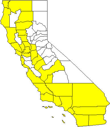
I have been to 34 out of 58 counties in California.
For a very clear map with the county names, visit Delorme's California
Counties page.
Do you have a postcard of California? If you do, please visit my State Postcard Collection page.
Return to my home page.
