Geography 100
Final Exam Review Questions |
|
The format of the Final Exam is 10 multiple
choice questions, 10 matching (word bank), 4 short answer
and a pick of 1 essay question from a selection of 3. The exam covers Lecture
#11 Hurricanes/Severe Weather through Glaciers in Lecture #20. The time limit is 1:50 minutes (likely you
will only need 1 hour). You may bring a calculator. This practice exam is the same
format as the actual exam and you should take it as if it is the real thing. Try to do this exam so that you
know how to budget your time and what to study. Read questions carefully. Good luck! |
Section A:
Multiple Choice (10 pts)
Circle the best
answer
1. The _______ stage of a
thunderstorm is most likely to produce a tornado. a. dissipation b. cumulus c. mature d. cirrus 2. The Intertropical
Convergence Zone helps produce this climate zone: a. A (Tropical) b. B (Dry) c. C (Midlatitude) d. E (Polar) 3. Over the past 150 years, global
warming has occurred everywhere on Earth: this statement is ______. a. True b. False c. uncertain, scientists do not know 4. The proportion of all fresh
water on Earth is about ______ of all water on Earth. a. 40% b. 50% c. 10% d. 3% 5. The a. dendritic b. trellis c. continental d. maritime 6. Underground water is stored
in ________. a. regolith b. aquifers c. bedrock d. watersheds
7. The ability of water to flow
through soil is controlled by its _____. a. color b. texture c. permeability 8. The crust of the Earth
"floats" on top if this plastic-like flexible layer. a. asthenosphere b. outer core c. thermosphere d. rift zone 9. The a. braided stream b. nick point c. basin divide d. delta 10. The breakup of exposed
bedrock by freezing and thawing of water in cracks is a type of _____. a. weathering b. mass wasting c. denudation d. both a and c are correct |
|
Section B: Matching (10 pts) |
|||||||||||||||||||||||||||||||||||||||||||
|
A. scouring |
B. D |
C. ice cores |
D. ocean currents |
E. glacier |
|||||||||||||||||||||||||||||||||||||||
|
F. E |
G. elevation |
H. volcanic activity |
I. El Niño |
J. written records |
|||||||||||||||||||||||||||||||||||||||
|
K.
La Niña |
L.
spit |
M.
plate tectonics |
N. erratic |
O.
sand bar |
|||||||||||||||||||||||||||||||||||||||
|
P. deposition |
Q. weathering |
R. continental
drift |
S. hurricanes |
T. tornadoes |
|||||||||||||||||||||||||||||||||||||||
Questions: |
|||||||||||||||||||||||||||||||||||||||||||
|
1. Cape Cod and much of South
East Massachusetts formed about 10,000 years ago as a _______ retreated
northward. 2. This modern theory
correctly describes why the crust of the Earth is slowly evolving. 3. Freezing of water
between cracks in rocks is part of this process that breaks down the solid
Earth. 4. Unusually warm water
off the coast of 5. The sediment (sand and other small particles) dropping to the bottom of the stream as it slows down is called ______. 6. Which Köppen climate zone does not occur in the Southern Hemisphere. 7. This climate control
keeps 8.
The Saffir-Simpson scale refers to ________. 9. Long-term climate change of the past 100
thousand years is extracted by scientists from ______ . 10. This type of coastal landform extends from the
mainland into the ocean ________. |
|||||||||||||||||||||||||||||||||||||||||||
|
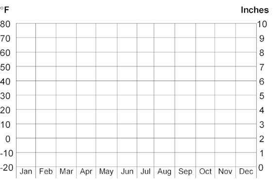
Section C: Short Answer (10 pts) 1. (5 pts) Plot the information in the table on the climograph below: a. The maximum temperature is
__________ °F and occurred in the
month of __________________.
|
|||||||||||||||||||||||||||||||||||||||||||
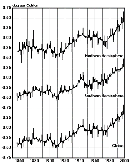
3. (2 pts) The three plots below show the global mean annual
temperatures over the past 150 years.
What is the difference between the amount of warming in the Northern
and Southern Hemispheres?
Explain in a few sentences what is causing the difference.
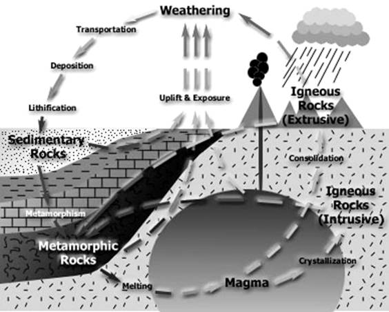
4. (1
pt) In the diagram
below, name the type of rock formed in the location of the box. Fill in the box
with the type of rock.

5. (2 pts) Name and define two types of coastal features that form by the transport of sand.
Section D: Essay (10 pts)
a.
Define
the underlined terms in the question (this should be done at the
beginning: 3-5 sentences)
b.
Discuss how the topic relates to changes in patterns related to
physical geography. Relate your answer to changes in space, place, and time and discuss why
is what where and so what? (3 to 5 sentences)
Provide your geographic insight on the relationship of the topic to physical and/or
human geography. Include the benefits and hazards to humans and our
environment. Best answers would base insight (impressions) on facts from the
book and lecture. (2 to 5 sentences)
Questions to chose from:
2. Discuss at least four (4) controls on climate.
Give examples of each one. How is the climate in
3. Discuss “Global Warming,” including: greenhouse
gases emitted by human activities, the time period of the enhanced
greenhouse effect, the differences between the warming in the Northern and
Southern Hemispheres, and the extent of warming/cooling for different regions
on Earth. Include a discussion of the outcome (consequences) of this global
warming. Include a brief discussion of how sure (certain) the experts are about
global warming. What can be done to decrease “global warming”.
Be sure to conclude with your geographic opinion of this topic.
4. Define the rock cycle. What are the three
primary types of rocks formed by this cycle? Define plate tectonics.
Discuss the three basic types of plate boundaries formed between moving
plates. Which type causes mountains to build? Which causes Earth Quakes in
5. Discuss how weathering and mass wasting affect the rock cycle. Define weathering and mass wasting. Discuss the 3 types of weathering (mechanical, chemical, and biological) and include examples of each one. Finally, describe how creep, falls, flows, slides and slumps cause mass wasting. Be sure to conclude with your geographic impression (opinion) of this topic.
6. Describe
the formation of glaciers and what causes them to advance (grow) and
recede (melt). Why are mountain glaciers important for people living in
the B climate zone. Name two landforms produced
after a glacier melts back toward the poles. What will happen to glaciers
and global sea-level if Global Warming continues.
Be sure to conclude with your geographic opinion of this topic.
|