|
On November 21, 1990-the day before Thanksgiving-Bill Irwin, 50, arrived at the base of Mount Katahdin in Maine's Baxter State Park, thus completing a walk of the footpath known as the Appalachian Trail. Irwin's goal of hiking the entire Trail began on March 8, 1990. His excursion through extensive wilderness in 14 states included 8 national forests and about 60 state parks and game lands.
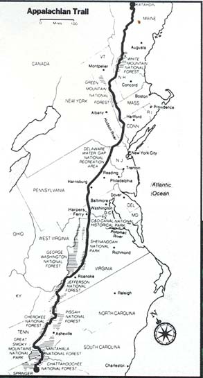
Unlike most thru-hikers- those attempting to walk the entire 2,144 miles of the Trail starting from Springer Mountain in northern Georgia to Mount Katahdin in one hiking season- Irwin's accomplishment attracted a great deal of national attention because of his disability. Irwin, a chemist turned Christian counselor from Burlington, North Carolina, is the first blind person (light perception but lacks visual acuity) to ever complete the walking Trail.
The Appalachian Trail Conference (ATC) located at Harpers Ferry, West Virginia, maintains and manages the trail. Completed in August of 1937, the Trail has become known as the world's longest continuously marked footpath, and in 1968 was designated by Congress as the country's first national scenic trail. The Trail follows the crests of the Nantahala and Great Smoky Mountains of North Carolina, the Blue Ridge Mountains from North Carolina to Pennsylvania, and ends with the Berkshire Highlands and the Green, White, and Mahoosuc Mountains in New England.
Most Trail users are day-hikers or backpackers who take trips of several days or weeks. According to records kept by A TC, about 1,000 hikers attempt the thru-hike each year but generally fewer than 200 succeed. Irwin was the last thru-hiker to complete the Trail in 1990, averaging 8.2 miles a day and finishing three and one-half weeks behind the next to last hiker of the year. As Irwin put it, "I was last by a landslide."
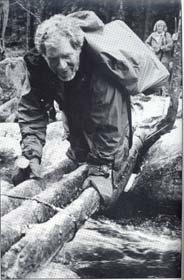 photo, Alice Cary, Freelance Features |
Unlike most thru-hikers, Irwin did not use the ATC's Official Guides to the Appalachian Trail which contain detailed descriptions and topographic maps. Instead, his son, Billy, made audio cassette tapes containing information about the Trail from Georgia to the Delaware Water Gap in Pennsylvania, and Laurie Peele, an ATC staff member, volunteered to supply tapes for Irwin from the Water Gap to Mount Katahdin. The tapes, which reached Irwin by mail during the course of his journey, contained such pertinent information as mileage between major landmarks and streams, locations of shelters, huts, hostels, stores, post offices, bed and breakfasts, all-you-can-eat restaurants, and people on the trail who are friendly and welcome thru-hikers. Most information for the tapes came from two ATC resources: Appalachian Trail Date Book and The Philosopher's Guide: Tips for A.T. Thru-Hikers (currently known as The Thru-Hikers Handbook, 1991).
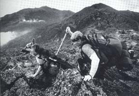
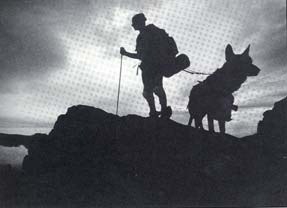
The ATC discourages hiking alone. Irwin's companion for the eight-month hike was a German shepherd guide dog named Orient. Both Orient and a ski pole carried by Irwin were used to assist with orientation and mobility.
 Bill Greene, The Boston Globe |
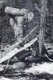
Rocks, cliffs, ledges, streams, and bridges were all formidable obstacles to navigate. Orient helped Irwin interpret conditions by changing the pace, hesitating, and placing his feet in a careful and deliberate manner. "It was truly a team effort, " explained Irwin. "There were times when Orient lost his footing and I could steady the leash attached to the dog's guide harness before he fell and there were other times when Orient helped to prevent me from falling."
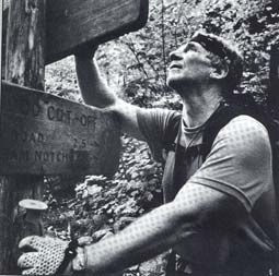
Along the Trail, Irwin and Orient were known as the Orient Express by fellow hikers. This reputation was based on their ability to locate and follow the Trail. "I was able to read the Trail signs with my fingers most of the trip," said Irwin. "The signs were cut deep into the wood with a router enabling me to deduce the names of the trails and mountains, direction and mileage." The two areas where signs were not available were the Shenandoah Valley and Connecticut.
In the Shenandoah Valley the Trail signs were made of small metal strips with embossed letters too small to read and in Connecticut the signs were out of reach to prevent vandalism. Fellow hikers, who met Irwin in these regions, attached sticks to signs or posts along the Trail to point out directional changes at various junctions. To start off in the right direction each morning, Irwin would pitch the front of his tent pointing north.
 |
"Orient developed a sense and feel for the Trail," noted Irwin. "Many times he would get us back on the Trail when we got lost by picking up the scent of other hikers. About half way through our journey, I feel that Orient was also able to spot Trail markers known as blazers (white markers, 2" wide by 6" long, placed on trees just above eye level). Orient was also able to identify trail makers known as cairns (piles of rock) found along the alpine summits in the White Mountains of New Hampshire." When Irwin did lose his orientation, he would blow a whistle and wait for another hiker to assist him; such help usually came along within several hours.
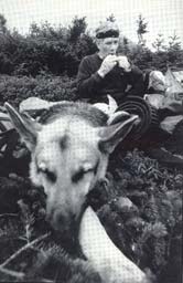
Although Orient's health was good throughout most of the trip, he did experience some difficult times. In the first few days of the trip, severe abrasions appeared on Orient's front legs, caused by friction created by the guide harness and backpack. Irwin carried Orient's pack for the next three weeks until the sores healed. Orient's backpack contained about 20 Ibs of supplies, including a high protein diet for working dogs.
On two additional occasions, Orient's feet were traumatized, once due to ice conditions in the Smokey Mountains (a foot of snow that melted and glazed over causing a sheet of ice). Irwin 'had to rest Orient in a lean-to for several days until the ice and snow melted and the feet healed. On another occasion in Pennsylvania, sharp shells cut Orient's feet requiring another five days of recuperation.
Many thru-hikers have packages mailed to them along the Trail. A ten person support group from the People's Memorial Christian Church in Irwin's hometown of Burlington, North Carolina, sent packages to post offices three weeks in advance of where Irwin was hiking the Trail. Every five days Irwin left the Trail for a package sent from Burlington and every twelve days he left the Trail to take a bath and wash clothes.
 Alice Cary, Freelance Features |
"My boots took a harder beating than most hikers'," explained Irwin. "Since I could not see where I was putting my feet, sharp rocks, streams, and weather conditions helped to wear out seven pairs of boots." Irwin also broke six ski poles and three pack frames during his 259-day expedition.
In any hiking situation, falls are anticipated. On occasions when Irwin fell backwards, he used his pack to help absorb the shock of falling. He preferred climbing uphill since falling down would be a shorter distance and not as traumatic. In Pennsylvania Irwin broke a rib when falling on top of a rock, causing him to call a friend in Burlington to come north and carry his pack for a week.
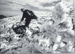
The last 432 miles of Irwin's hike through New Hampshire and Maine were the most difficult. The Trail becomes a pathway across the seven rugged and beautiful Presidential summits in New Hampshire. Much of the Trail is above timberline and known for its Alpine elevation (above 4,800 ft), stark summits, gorges, boulder-strewn ravines, and water cascades. In Maine the Appalachian Trail is considered the most remote because it leads through the greatest and most isolated wilderness in the Northeast.
 Alice Cary, Freelance Features |
During October the weather conditions were very bad. It rained all but three days and sometimes the wind reached 60 miles an hour with a wind chill of 48-70° below zero. The Appalachian Mountain Club (AMC) staff headquartered at Pinkham Notch, at the base of Mount Washington, was concerned about Irwin being in such adverse weather conditions for days at a time.
The AMC provided Irwin with a radio. Several times a day he called headquarters to inform the staff of his location and weather conditions. During the last three weeks, David McCasland, a writer and friend, accompanied Irwin. Irwin and McCasland assisted each other in their attempts to forge the many swollen streams caused by days of rain.
"I became hypothermic several times," Irwin reminisced. "The terrain in the mountains was ice and snow covered. I had to walk with crampons (metal plates containing 1/2" spikes) strapped to my feet for two days. There were times when I could not untie my shoes, take the cap off my head, or feed Orient At times I lost total control of my hands because I was so cold. Had I been alone, I would not have made it."
Irwin spent one night with the staff of Mount Washington Weather Observatory because weather conditions prohibited him from making it to his intended destination before nightfall. Mount Washington (6,288 ft) is the highest peak in the Northeastern United States.
Buzz Caverly, Superintendent of Baxter State Park, was concerned about Irwin completing the Trail. Caverly suggested that Irwin climb Mount Katahdin (5,267 feet), the northern terminus of the Trail, before the weather prevented his ascent Irwin left the Trail at Stratton, Maine (184 miles form Katahdin's summit), and completed the hike of the mountain on October 24; returning to Stratton on the 25th. Four weeks later (November 21st), Irwin arrived at the base of Mount Katahdin, thus completing a journey of a lifetime and adding his name, as well as Orient's, to the roster of accomplished hikers known as 2,000 milers. On the day after Thanksgiving the mayor of Millinocket, Maine, a community located just south of Baxter State Park, honored Irwin by asking him to ride in the Christmas Day Parade and awarding him the Key-to-the-City. Irwin returned home to complete a book about his travel; it is due in bookstores November, 1991.
One might think that Irwin has done it all-- but he hopes to continue hiking and plans to tackle the Long Trail next, a 265-mile path that runs the length of Vermont along the crest of the Green Mountains.
|