Brockton Seal

This page is a resource for my first-year seminar students and others who wish to learn about the physical and human geography of Brockton, Massachusetts. As I continue to learn about the city, I welcome suggestions and corrections! I may be reached at jhayesboh@bridgew.edu.

This course was last offered in Fall 2008, but is coming back for Fall 2014, as an Honors course! Once again, it will meet just one afternoon a week, to facilitate field trips in Brockton. Students will work diligently online between these meetings.
Geography of Brockton - Population 93,810
Resources for Learning about The City of Champions
UPDATED January 28, 2014

James Hayes-Bohanan, Ph.D.
Chair, Department of Geography
Bridgewater State University

First Year Seminar - Brockton
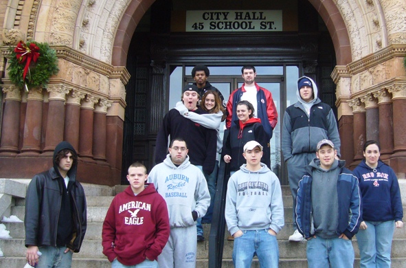
First-Year Seminar students on tour of Brockton, December 8, 2007


LOCAL

The City of Brockton web site provides services for residents and general information about the city, including a bit of history, climate, demographic data and a few maps.

Count on librarians to organize information, even online! The Brockton Public Library System has a Brockton Information page with links to the best information. Plan to visit one of the library branches to learn even more!

Managing Land for Water is a presentation I gave to the D.W. Field Park Association in 2006. It describes the geographic factors that have led to Brockton's rather extreme water shortages. It was actually while working on that presentation that I got the idea to offer this course. This document includes the PowerPoint used in the presentation and links to the sources I used to prepare it. Amy Crawford's 2013 article Tapped Out provides a detailed update on the water project that has become a financial burden on the city, without supplying any water at all most years.

Brockton has been called the Eleventh Island of Cape Verde, and Cape Verdeans are an intergral part of the cultural fabric of the city. The Associação Cabo-Verdiana de Brockton has been promoted, assisted, and served this part of the community since 1977. Learn more about my own involvement in Cape Verde -- and about my next study tour -- at my Sustainable Development in Cape Verde page.

Brockton.NET is a portal for community organizations and resources -- and political chat!

Old Colony Planning Council has a long-established relationship with the Department of Geography and employs a number of alumni. It is a great source of information about planning and transportation issues in a number of communities, including Brockton.

The web site of the Brockton Historical Society is not actively maintained (as of June 2007), but it includes descriptions of several of the city's important museums and historic sites. The organizers exhibit a great deal of pride in the city! The "About Us" link is an article a response to those who have disparaged Brockton.

The USGenWeb has a Brockton site for geneologists -- who are among the best local historians -- maintained by Brockton native Dale Cook.

A shtetl is from the Yiddish word for "village." It can be used to describe Jewish communities, such as the community that flourished around Bay and Crescent Street in Brockton in the 1940s and 1950s. Learn all about it on the Brockton ShtetLink geneology resource page created by Steven Weiss.


See Venetian Princess and the rest of my Brockton YouTube playlist!

Venetian Princess - Brockton


Brockton Brightfields

Learn about the Brockton Brightfield from the Sietch blog.

STATE

The State of Massachusetts official web site includes information about communities statewide and many of the issues that concern communities, including education, environment, economic activity, and transportation. See the Brockton community page in particular.

Mass
                GIS
The Online Mapping page at MassGIS includes Oliver and other tools for making your own maps of Brockton -- or any other part of the Commonwealth!

About a century ago, Sanborn Fire Insurance Maps covered urban areas areas throughout the United States. Today, the maps are of great value to researchers. It is sometimes possible to find paper copies in special collections of public libraries. The entire collection is available in digital form (as images -- not GIS layers) from UMI. The Maxwell Library at Bridgewater State University subscribes to the Massachusetts collection, which is used extensively in this course. Find the link (titled "Digital Sanborns" and instructions for off-campus use on the Maxwell Electronic Resources page.
Sanborn Geospatial Solutions

Matt Carroll of the Boston Globe posts town-level statistics on everything from car crashes to doughnut shops every Thursday. Have a look at the "Your Town" section of the Government Center web page for a list of these lists. We will write about some of them in class.

GLOBAL

Use Google Maps to explore from any browser.
Download Google Earth to your laptop to make your own maps for class projects.

Use Live Search to get amazing images of a location from a variety of perspectives. (See the Brockton Public Library as a good example -- use the buttons to rotate the point of view, and then explore the city, changing your angle as you do!)

The U.S. Census Bureau has all kinds of demographic and business data -- including latest estimates and maps for Brockton.

Use GeoNames at USGS to find the other Brocktons in Alabama, Georgia, Montana, Pennsylvania, and South Carolina.
Explore Brockton with Google Maps


Back to the Environmental Geography page.

Visitors since June 29, 2007